
Items that need to rolled up and shipped in a tube
New copies of the Society’s publications that are available to purchase are shown below, the oldest being Berkeley Square to Bond Street, The Early History of the Neighbourhood published in 1952.
Second-hand copies of some 1951-2001 publications are listed here. Please contact Roger Cline to ascertain availability and cost.
CUSTOMS REMINDER
The shipping charge does not include payment of any charges that may be applied by customs authorities. Payment of any such charge is the purchaser’s responsibility.
-
 Select options
This product has multiple variants. The options may be chosen on the product page
Select options
This product has multiple variants. The options may be chosen on the product page
A Plan of the Tower of London in 1682
£6.70
-
 Select options
This product has multiple variants. The options may be chosen on the product page
Select options
This product has multiple variants. The options may be chosen on the product page
Barker's Panorama of London from the Roof of the Albion Mills, 1801
£9.60
-
 Select options
This product has multiple variants. The options may be chosen on the product page
Select options
This product has multiple variants. The options may be chosen on the product page
Charles Booth's Descriptive Map of London Poverty 1889
£17.75
-
 Select options
This product has multiple variants. The options may be chosen on the product page
Select options
This product has multiple variants. The options may be chosen on the product page
Charles Robert Cockerell's Tribute to Sir Christopher Wren
£17.75
-
 Select options
This product has multiple variants. The options may be chosen on the product page
Select options
This product has multiple variants. The options may be chosen on the product page
Facsimile of the Ordnance Surveyors' Drawings of the London Area 1799-1808
£24
-
 Select options
This product has multiple variants. The options may be chosen on the product page
Select options
This product has multiple variants. The options may be chosen on the product page
Hollar's The Prospect of London and Westminster taken from Lambeth (2 versions)
£9.60
-
 Select options
This product has multiple variants. The options may be chosen on the product page
Select options
This product has multiple variants. The options may be chosen on the product page
Jan Kip's Prospect of London 1720
£29.55
-
 Select options
This product has multiple variants. The options may be chosen on the product page
Select options
This product has multiple variants. The options may be chosen on the product page
Joel Gascoyne's Engraved Maps of Stepney, 1702-04
£23.00
-
 Select options
This product has multiple variants. The options may be chosen on the product page
Select options
This product has multiple variants. The options may be chosen on the product page
London from the North, by J. Swertner, 1789
£6.70
-
 Select options
This product has multiple variants. The options may be chosen on the product page
Select options
This product has multiple variants. The options may be chosen on the product page
Map of the Geology and Contours of London and its Environs, by R. W. Mylne (1856)
£18.80
-
 Select options
This product has multiple variants. The options may be chosen on the product page
Select options
This product has multiple variants. The options may be chosen on the product page
Map of the Railways proposed by the Bills of the Session of 1863 in the Metropolis and its vicinity
£6.70
-
 Select options
This product has multiple variants. The options may be chosen on the product page
Select options
This product has multiple variants. The options may be chosen on the product page
Satellite View of London, taken by Landsat on 21 October 1984
£6.70
-
 Select options
This product has multiple variants. The options may be chosen on the product page
Select options
This product has multiple variants. The options may be chosen on the product page
Survey of Hatton Garden by Abraham Arlidge 1694
£6.70
-
 Select options
This product has multiple variants. The options may be chosen on the product page
Select options
This product has multiple variants. The options may be chosen on the product page
The 'Rhinebeck' Panorama of London, 1807-11
£17.75
-
 Select options
This product has multiple variants. The options may be chosen on the product page
Select options
This product has multiple variants. The options may be chosen on the product page
The Artillery Ground and Fields in Finsbury, two maps of 1641 and 1705
£9.90
-
 Select options
This product has multiple variants. The options may be chosen on the product page
Select options
This product has multiple variants. The options may be chosen on the product page
The Banqueting House with the Whitehall and Holbein Gates c.1623
£6.70
-
 Select options
This product has multiple variants. The options may be chosen on the product page
Select options
This product has multiple variants. The options may be chosen on the product page
The Kentish Town Panorama drawn by James Frederick King
£10.35
-
 Select options
This product has multiple variants. The options may be chosen on the product page
Select options
This product has multiple variants. The options may be chosen on the product page
The London Panoramas of Robert Barker and Thomas Girtin, c. 1800
£8.90
-
 Read more
The Panorama of London circa 1544, by Anthonis van den Wyngaerde
£
-
 Select options
This product has multiple variants. The options may be chosen on the product page
Select options
This product has multiple variants. The options may be chosen on the product page
The Whitehall Palace Plan of 1670
£13.60
-
 Select options
This product has multiple variants. The options may be chosen on the product page
Select options
This product has multiple variants. The options may be chosen on the product page
Thomas Milne's Land Use Map of London and Environs in 1800 (LTS 118 & 119)
£17.75
-
 Select options
This product has multiple variants. The options may be chosen on the product page
Select options
This product has multiple variants. The options may be chosen on the product page
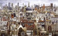
Two thousand years of London - a signed limited edition print by the topographical artist Andrew Ingamells
£65